Thinking about a waterfront lot in South Mount Pleasant, south of the IOP Connector? The views and lifestyle are compelling, but the details matter. Shorelines here range from tidal creeks and marsh to riverfront, and each setting changes what you can build, how you access the water, and how long permits take. In this guide, you’ll learn how to evaluate dock potential, flood risk, utilities, and permitting so you can move forward with confidence. Let’s dive in.
What “waterfront” means here
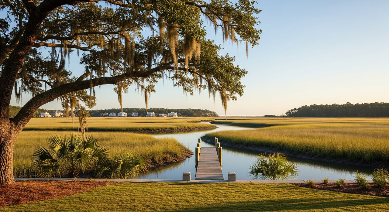
South Mount Pleasant parcels touch a mix of tidal creeks, salt marsh, the Wando River, Charleston Harbor tributaries, and interior canals. Many lots are “marshfront,” which means your shoreline is a vegetated intertidal area rather than open water. That often affects dock length, construction type, and approvals. Understanding your exact water type is step one in judging feasibility and value.
Jurisdictions overlap here. You will interact with the Town of Mount Pleasant, Charleston County, South Carolina’s coastal regulators, and federal agencies. Each has different rules. Plan around all layers to avoid costly surprises.
Start with survey and title
Order a current, detailed boundary/topographic survey. Ask your surveyor to show parcel corners, elevations, and the mean high water (MHW) and mean low water (MLW) lines. Accurate tidal lines help you understand ownership limits and where docks or structures could start. For tidal datums and local tide information, review the resources in NOAA Tides & Currents.
Request a title report that confirms fee title to uplands and notes any state ownership of submerged lands. Look for recorded easements, rights of way, and any HOA or CCR rules that limit docks or shoreline work. If an existing pier or bulkhead is present, ask for prior permits and as‑builts.
Ask your surveyor to include:
- Parcel area, contours, and spot elevations near the shoreline
- MHW/MLW lines and any encroachments
- Existing structures, docks, bulkheads, and utilities
- Recorded easements and restrictions
Access and navigability
Clarify how you reach the lot: public road frontage, a private easement, or through a community dock. Then confirm your water access type: riparian upland frontage, marshfront, canal, or deepwater. If a tidal channel or marsh separates you from open water, you may need a longer pier or a different structure.
Boat size and draft matter. A local marine contractor can assess typical water depths and navigability for your intended use. Document this early so it aligns with your dock strategy and expectations.
Dock and shoreline feasibility
Dock feasibility depends on shoreline type and regulations. Docks over marsh or into navigable waters commonly require state and federal approvals plus local permits. Review requirements with South Carolina’s coastal office, the Town, and the U.S. Army Corps.
- Town of Mount Pleasant planning and permitting provides local standards on piers and shoreline work. Start with the town’s site at the Town of Mount Pleasant.
- South Carolina’s coastal program reviews docks, bulkheads, and consistency with state rules. See the Office of Ocean & Coastal Resource Management via SCDHEC.
- Federal permits for structures in navigable waters and wetland impacts are handled by the U.S. Army Corps of Engineers.
If you are marshfront, expect that a dock could be longer and may face limits or added scrutiny. If a bulkhead exists, consider its condition and any replacement or reinforcement needs. Confirm who pays for shared structures in HOA documents.
Wetlands and environmental limits
Identify any jurisdictional wetlands and waters on or near the parcel. Filling or grading marsh typically triggers rigorous permits and possible mitigation. Site reviews may also consider protected species and essential habitat.
For habitat and navigation guidance, consult the South Carolina Department of Natural Resources. A wetlands consultant can help delineate boundaries and shape a permit strategy before you commit to a design.
Flood zones, elevation, and insurance
Pull the FEMA Flood Insurance Rate Map (FIRM) panel and Flood Insurance Study for the parcel. Confirm your zone (AE, VE, or X), the Base Flood Elevation (BFE), and any coastal high‑hazard criteria that affect construction methods and finished-floor heights. An elevation certificate tied to NAVD88 will help with design and flood‑insurance estimates. Start with FEMA’s mapping and NFIP resources at FEMA.
Account for relative sea level, subsidence, and erosion when considering buildable area and long‑term resiliency. Ask your insurance professional for a preliminary premium range and discuss Increased Cost of Compliance and floodplain limitations.
Utilities and septic vs. sewer
Confirm public sewer and water availability early. Verify connection capacity, tap fees, and any phasing or moratoria with the local provider. If sewer is not available, you will need a septic system that meets county health standards, which depends on soils, groundwater, and setbacks. Identify electrical and communications options and any utility easements that shape house and dock placement.
Stormwater is a key design item on low‑lying lots. Expect specialized drainage controls consistent with local stormwater requirements.
Soils and foundations
Coastal soils often include sands, organics, or past fill, which can point to pile foundations for homes and piers. Order geotechnical borings if you plan to build, add a seawall, or install a drainfield. High groundwater can affect septic feasibility and foundation design. For septic, secure county health permits and current soil suitability tests.
Zoning, setbacks, and tree rules
Confirm your zoning district, shoreline buffers, and setback requirements with the Town. Ask about maximum pier dimensions, shoreline stabilization standards, coverage, impervious limits, height, and vegetation removal rules. Start your review at the Town of Mount Pleasant. For parcel records and county mapping tools, use Charleston County resources.
If an HOA is involved, review its dock, bulkhead, lighting, and rail standards alongside municipal rules.
Timelines, costs, and smart contingencies
Local site reviews can take weeks to a few months. State and federal permits for docks or fill can take months, and complex cases may run 6 months or more. Coastal lots usually carry higher costs for pile foundations, engineered seawalls, longer piers, specialized contractors, and insurance.
Common causes of delay include the need for an individual federal permit, wetland mitigation, septic redesigns, and appeals. Build this into your budget and closing timeline.
Use this buyer checklist:
- Order a current survey and elevation certificate; start title review
- Confirm sewer and water availability; verify tap fees and capacity
- Get a marine contractor’s dock feasibility opinion
- Pull FEMA zone and BFE; request a preliminary flood‑insurance estimate
- Screen for wetlands and habitat constraints
- Model permit timelines and include appropriate contingencies
Your local team
Engage specialists early so you can bid, budget, and design with clarity.
- Licensed land surveyor for boundary, MHW/MLW, topo, and elevations
- Marine contractor or pier builder with South Carolina experience
- Civil/site engineer with coastal experience for grading, stormwater, and seawalls
- Geotechnical engineer for borings and foundation recommendations
- Environmental/wetlands consultant for delineations and permit strategy
- Local permit expeditor for Town and County submittals
- Real estate attorney with coastal experience for deed and riparian rights
- Title company or closing attorney for title insurance and exceptions
- Arborist if protected canopy trees are present
Red flags to pause on
- The mean high water line cuts through the yard or title mentions submerged or sovereign lands
- Marshfront with no navigable channel, making a private dock impractical or very costly
- Existing dock lacks a record of prior permits
- Old or absent septic approvals with marshy soils or high groundwater
- Multiple easements or community bulkhead agreements that constrain dock placement
- VE or coastal high‑hazard zones that require elevated or pile construction
Next steps
A winning approach in South Mount Pleasant is simple: verify the shoreline and title, confirm utilities, vet dock feasibility, and map out the permit path before you close. Use public resources from the Town of Mount Pleasant, Charleston County, SCDHEC’s coastal office, the U.S. Army Corps of Engineers, FEMA, NOAA Tides & Currents, and SCDNR to ground your decisions.
If you want seasoned guidance and discreet representation on a high‑value waterfront acquisition, let’s talk. Robertson Allen pairs deep local stewardship with white‑glove execution so you can pursue the right lot with confidence.
FAQs
Can you build a private dock on a marshfront lot in South Mount Pleasant?
- It depends on site specifics; docks over marsh often require longer piers and state, federal, and Town approvals, and some marshfront lots face limits or prohibitions on structures.
How do you confirm the FEMA flood zone for a Mount Pleasant waterfront parcel?
- Pull the correct FIRM panel and Flood Insurance Study through FEMA and obtain an elevation certificate tied to NAVD88 for accurate design and insurance estimates.
Who permits docks and bulkheads on tidal creeks in Mount Pleasant?
- You typically need local approvals from the Town of Mount Pleasant, state coastal review via SCDHEC, and federal authorization from the U.S. Army Corps of Engineers.
What if public sewer is not available at a South Mount Pleasant lot?
- You will need a septic system approved through county health processes, which requires suitable soils and setbacks; high groundwater or marshy soils can complicate or prevent approval.
How long do state and federal permits for docks usually take in Charleston County?
- Review times vary by complexity, but plan for months; more complex cases can take 6 or more months based on agency review and potential mitigation requirements.
Which documents should you gather before writing an offer on a waterfront lot?
- Request a current survey, title report, FEMA zone and BFE, any prior permits or as‑builts for docks or bulkheads, HOA/CCR rules, and a utility availability confirmation.