You want the coastal lifestyle without giving up easy access to downtown Charleston. South Mount Pleasant offers that blend, with creeks and marsh views on one side and quick routes to the beaches on the other. If you are comparing neighborhoods here, the choices can feel wide-ranging. This guide breaks down the area by lifestyle, access, commute patterns and key buyer checks so you can narrow your search with confidence. Let’s dive in.
What locals mean by South Mount Pleasant
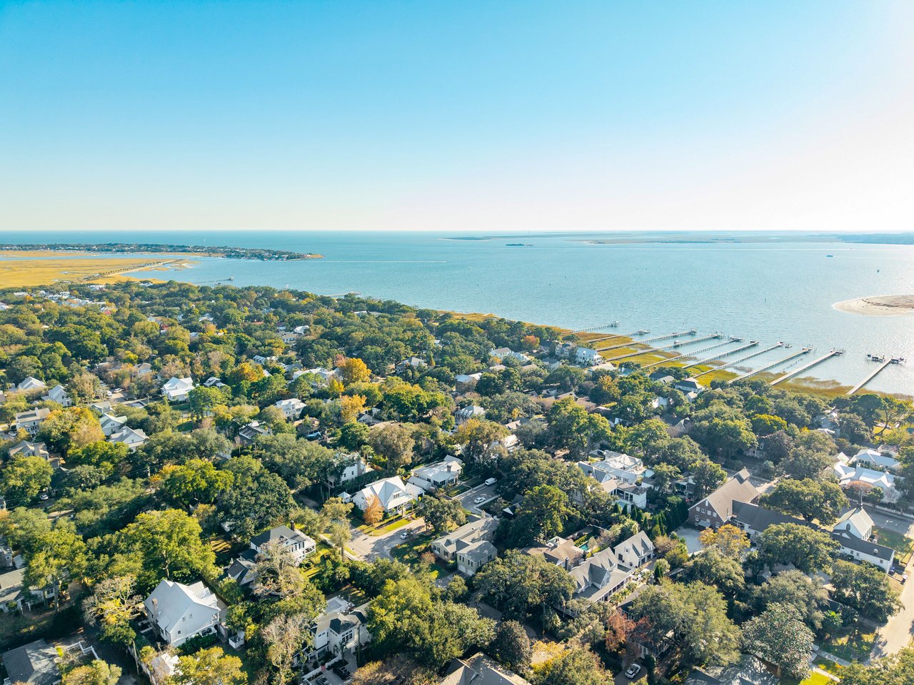
When people say “South Mount Pleasant,” they are usually talking about the part of town south of the central corridors around Coleman Boulevard and near the Isle of Palms Connector. You sit between downtown Charleston across the Ravenel Bridge and the barrier islands of Isle of Palms and Sullivan’s Island. The result is a daily routine that can flip between city dining and beach time with little effort.
- Downtown Charleston access: US‑17 over the Ravenel Bridge is the main route.
- Beach access: Isle of Palms is reached via the Isle of Palms Connector, also signed as SC‑517.
- Regional access: I‑526 connects you to the airport, West Ashley and North Charleston.
Neighborhood types at a glance
South Mount Pleasant offers a mix of waterfront enclaves, walkable corridors and planned communities. Your short list should start with how you want to live day to day.
Marshfront and creekfront
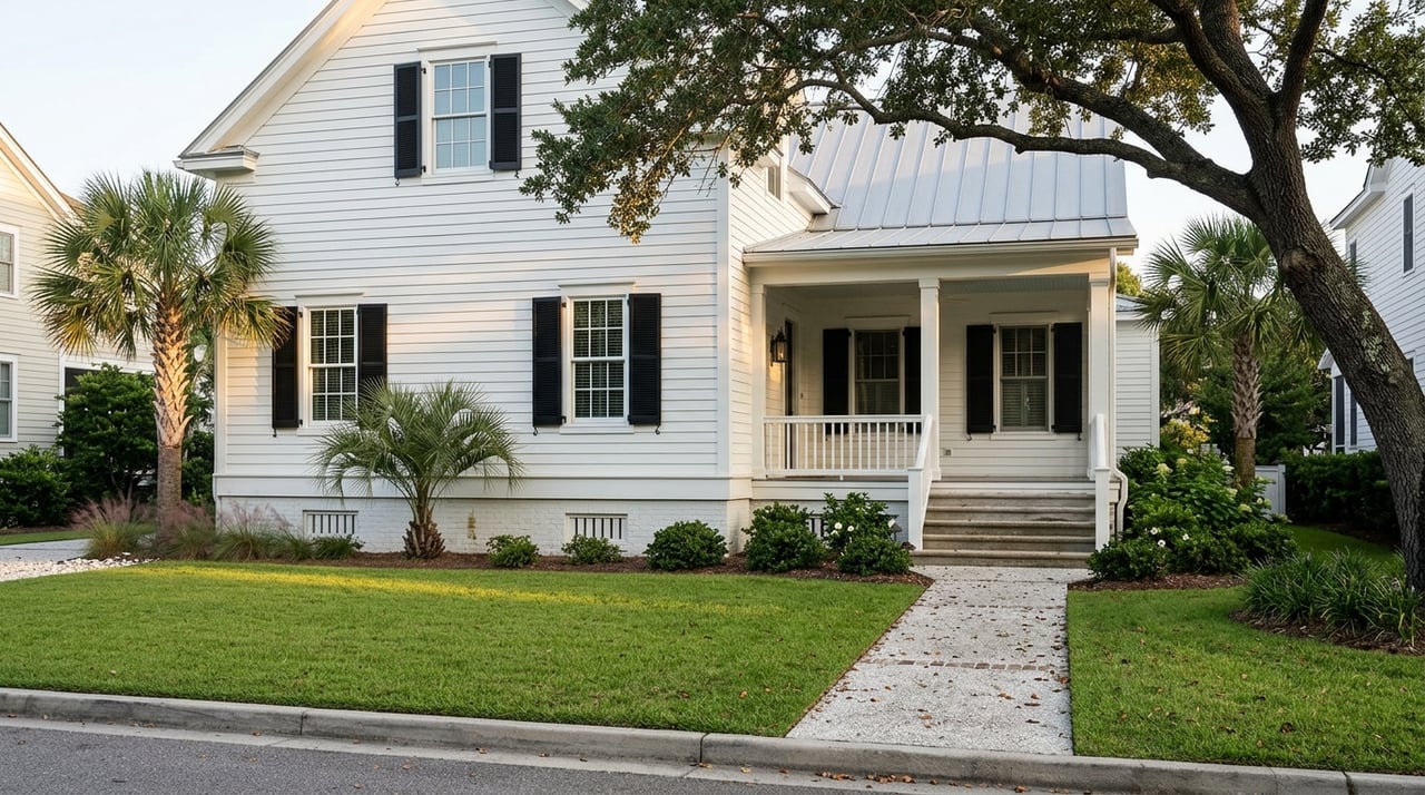
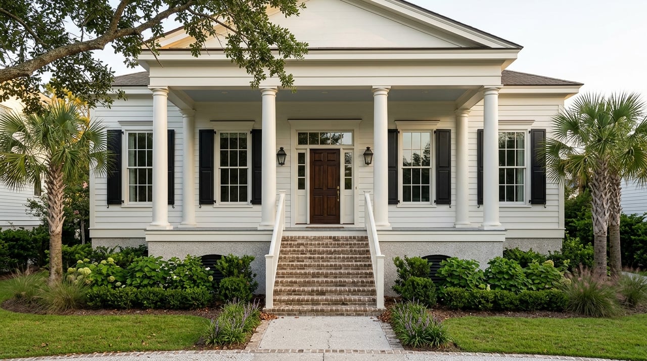
These pockets line tidal creeks and marshes and can offer private docks, wide views and a strong connection to the water. Many are a mix of classic cottages and newer builds. Maintenance is different here. Salt conditions, tidal range and bulkhead or piling upkeep should be part of your plan. If you want a boat in your backyard, confirm dock rights and permit history early.
Beach‑adjacent and connector‑close
Homes near the Isle of Palms Connector or Ben Sawyer corridors give you fast access to Isle of Palms and Sullivan’s Island without living on the barrier islands. This setup is popular if you want ocean time to feel like a quick errand. Expect heavier seasonal traffic near these routes, especially on summer weekends and holidays.
Planned communities and subdivisions
Inland master‑planned neighborhoods often include pools, sidewalks, trails, community centers and, in some cases, golf or shared docks. You will see a range of lot sizes and home ages, from newer construction to infill homes on smaller lots. HOA fees bring amenities and rules, so review documents and reserves as part of your diligence.
Mixed‑use and walkable corridors
Coleman Boulevard and the Shem Creek area offer condos, townhomes and residences near shops and dining. If you prefer to walk to dinner or launch a paddleboard nearby, this corridor can be a great fit. Street activity and commercial traffic vary by block, so preview at different times of day.
Infill and renovation pockets
Older cottages and mid‑century homes are common in several South Mount Pleasant pockets. Many are being renovated or replaced with custom builds. Buyers who want to put their stamp on a property often target these streets. Check zoning, lot coverage rules and utility connections to confirm what is feasible before you commit.
Lifestyle anchors and coastal access
Parks and green space
You will find neighborhood parks and sidewalks in many planned communities. For broader waterfront space, Mount Pleasant Memorial Waterfront Park is a favorite for walking the pier and enjoying the river views. For a true Lowcountry nature day with trails and picnic areas, explore Palmetto Islands County Park.
Marinas and boating
Shem Creek is the heart of local boating, with marinas, boatyards, fishing charters and a working waterfront vibe. If you plan to keep a boat, ask about deeded slips, marina waitlists and the condition of any private bulkheads or pilings. Documentation matters for long‑term maintenance and resale.
Beach and barrier‑island access
Isle of Palms is the closest ocean beach for South Mount Pleasant residents. You reach it via the Isle of Palms Connector. Public beach access points and parking come with seasonal rules, so review current guidelines on the city’s site before you go. For logistics, check the City of Isle of Palms page on beach parking and access.
Dining, retail and everyday errands
Shem Creek offers a cluster of seafood restaurants and casual spots right on the water. Coleman Boulevard anchors day‑to‑day needs like groceries, pharmacies and services. Many residents choose a home based on how often they want to walk or bike to these amenities versus driving.
Getting around: commutes and traffic
Primary routes
US‑17 over the Ravenel Bridge is the standard route to downtown Charleston. East‑west travel within Mount Pleasant relies on Coleman Boulevard, Ben Sawyer Boulevard and the Isle of Palms Connector. For trips to the airport or beyond, use I‑526 as a regional loop.
Commute time ranges
Outside peak periods, many trips to central Charleston take about 15 to 30 minutes. During weekday rush hours, expect 20 to 45 minutes or more depending on congestion and incidents. Summer weekends and holidays bring heavier traffic toward Isle of Palms and around Shem Creek. For real‑time updates, check SCDOT’s traffic resources before you head out.
Transit, biking and walkability
CARTA runs bus routes that cover parts of Mount Pleasant, though service is less frequent than core city routes. Explore CARTA to understand schedules and coverage. Biking infrastructure is improving in some corridors, but continuity varies by neighborhood. Walkability is highest near Coleman and Shem Creek and more car‑oriented in many subdivisions.
Buyer considerations and checklist
Housing stock and price spectrum
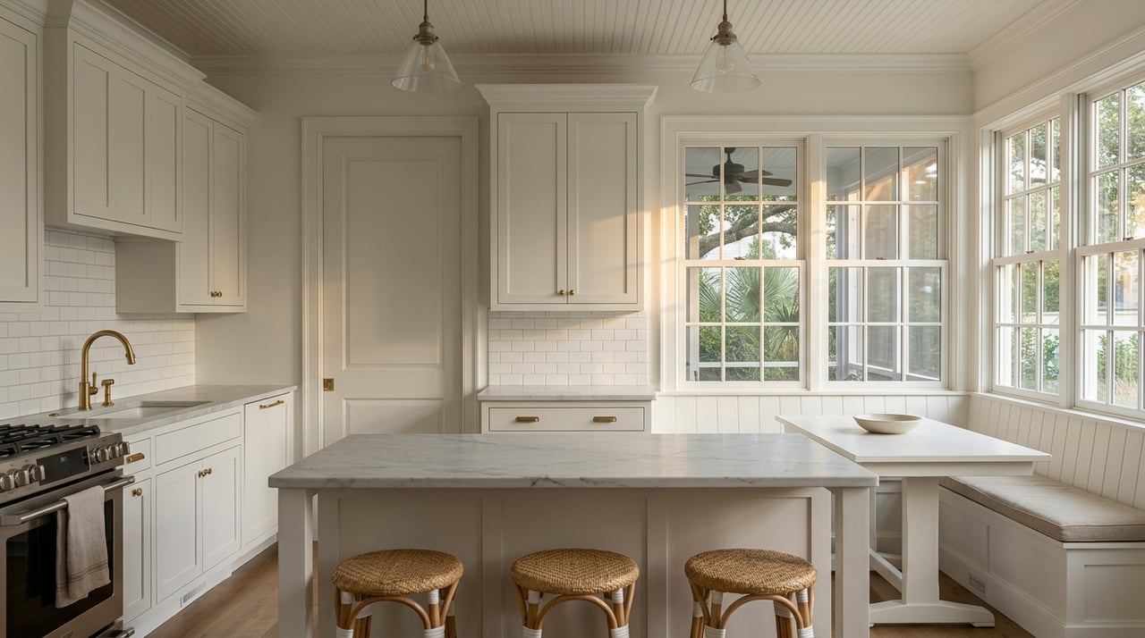
You will find a broad price range. Smaller inland homes and townhomes are typically on the lower end of the local spectrum. Marshfront, direct‑water and beach‑adjacent properties command premiums. New construction and custom builds add an upper tier. Condition, dock rights and proximity to open water can shift value within the same street.
Flood and insurance basics
Many low‑lying marshfront parcels fall within FEMA Special Flood Hazard Areas. Lenders may require flood insurance in these zones. Ask for an elevation certificate to understand base flood elevation and mitigation needs, such as elevated foundations. Compare both NFIP and private flood options, and obtain quotes early. To evaluate a specific address, start with the FEMA Flood Map Service Center and the NOAA Sea Level Rise Viewer for regional context.
Infrastructure and permitting
Most of Mount Pleasant uses municipal sewer, but confirm utility status for each lot, especially if you plan to expand or rebuild. If waterfront access is on your wish list, review dock and bulkhead permits and any recorded maintenance history. HOA rules, fees and shared facility obligations, such as community docks, should be part of your review.
Construction and renovation
Coastal building standards affect design and cost. Elevated foundations, hurricane‑rated components and corrosion‑resistant materials are common. Contractor demand can extend timelines for major work. Build realistic schedules into your plan and confirm availability early if you intend to renovate right after closing.
Zoning and development trends
The Town of Mount Pleasant maintains zoning maps and a comprehensive plan that influence infill and redevelopment intensity. Smaller lots near walkable corridors and waterfront areas often see redevelopment interest. Understanding these patterns can help you identify appreciation potential or plan a strategic sale.
Quick buyer checklist
- Confirm the FEMA flood zone and ask for an elevation certificate.
- Get preliminary flood and homeowners insurance quotes.
- Verify dock and bulkhead permits and maintenance history if water access matters to you.
- Drive your commute at rush hour and test your route to the beach on a weekend morning.
- Walk the lot to understand elevation, drainage and driveway flood paths.
- Review HOA documents, fees, rules and reserves.
- Confirm sewer availability, connection costs and any local assessments.
- Ask about salt‑air corrosion, HVAC age and coastal maintenance items during inspections.
Which areas fit your priorities?
If you want the fastest beach access
Look near the Isle of Palms Connector and Ben Sawyer corridors. You will trade a little seasonal traffic for quick ocean time. Confirm the closest public beach parking and any seasonal rules before peak season using the City of Isle of Palms resources on beach parking.
If you want walkable dining and water views
The Coleman Boulevard and Shem Creek corridor provides restaurants, marinas and a lively waterfront setting. Expect more activity and commercial traffic, which some buyers love and others prefer to avoid.
If you want private water access
Marshfront and creekfront pockets can offer docks and sweeping views. Focus on permit records, bulkhead condition and the type of water body. Tidal creeks differ from open water for navigation and maintenance.
If you want new‑build convenience
Planned communities and newer subdivisions deliver modern systems, sidewalks and community amenities like pools and trails. HOA fees bring predictable upkeep and shared spaces. Review rules to make sure they align with your lifestyle.
If you want renovation potential
Infill and renovation streets offer older homes that can be updated or replaced. Confirm zoning, setbacks, height limits and utility capacity early to ensure your plan is feasible.
Getting proactive about logistics
Beach days, boat days and city nights are all close when you live in South Mount Pleasant. The difference between a great fit and a compromise often comes down to the details. Drive your commute at peak hours. Visit the beach during a busy weekend to see traffic patterns. If boating is a priority, speak with marinas about slip availability or plan for trailered launches. For everyday errands, test how your grocery, pharmacy and gym run will feel from a short list of homes.
Work with a local steward
Choosing between walkable Coleman's energy, a quiet marshfront lane or a planned community with amenities should feel exciting, not overwhelming. A focused search anchored in flood and insurance due diligence, realistic commute testing and clear permitting checks will help you move with confidence. If you want a private, property‑specific plan that pairs lifestyle priorities with risk and cost clarity, schedule a consultation with Robertson Allen.
FAQs
What does “South Mount Pleasant” include?
- It generally refers to the Mount Pleasant area south of the central corridors around Coleman Boulevard, near Shem Creek and the Isle of Palms Connector, positioned between downtown Charleston and the barrier islands.
How long is the commute to downtown Charleston from South Mount Pleasant?
- Many trips take about 15 to 30 minutes off‑peak, and 20 to 45 minutes or more during rush hour, depending on congestion and incidents.
Where can I find rules for Isle of Palms beach parking?
- Review the City of Isle of Palms guidance on beach parking and access for current locations, hours and seasonal rules.
What flood precautions should I expect when buying near the marsh?
- Plan for an elevation certificate, evaluate base flood elevation and obtain early quotes for NFIP and private flood policies; start with the FEMA Map Service Center and NOAA Sea Level Rise Viewer for context.
Are there deeded boat slips available in South Mount Pleasant?
- Some condos and neighborhoods offer deeded slips or marina spaces, but availability and transfer rules vary, so request documentation and confirm waitlists with local operators.
Is there public transit service in South Mount Pleasant?
- CARTA runs routes that reach parts of Mount Pleasant, though coverage and frequency vary by corridor; check CARTA for current schedules and maps.